This Mangrove Management Plan, written in 1985 by one of Fiji’s foremost terrestrial biologists, Dr Dick Watling, while not formulated into law in the Fiji Islands, remain the only comprehensive study of Fiji’s mangrove areas available.
Together these plans comprised over 15,000 ha or about 35% of Fiji’s mangroves.
Maps were prepared of the mangrove resource with the mangroves allocated to alliances (dominant species’ associations which characterised the mangroves of the area and their assumed productivity). Separate maps were then prepared with a zonation overlay.
A hierarchical designation of zones was proposed so as to allow a degree of flexibility with the ‘Managed’ and ‘Development’ designated zones whilst affording maximum protection for the majority of the resource (Table 1 and Figure 2).
The overall purpose of the plan and the zoned maps was to provide the Mangrove Management Committee and Department of Lands with a framework for decision-making when development applications were received or when departmental licensing for specific purposes i.e. mangrove harvesting for timber.
The maps were also shown to developers to focus their attention on the need or not to convert mangroves, and/or direct their attention to more suitable sites.
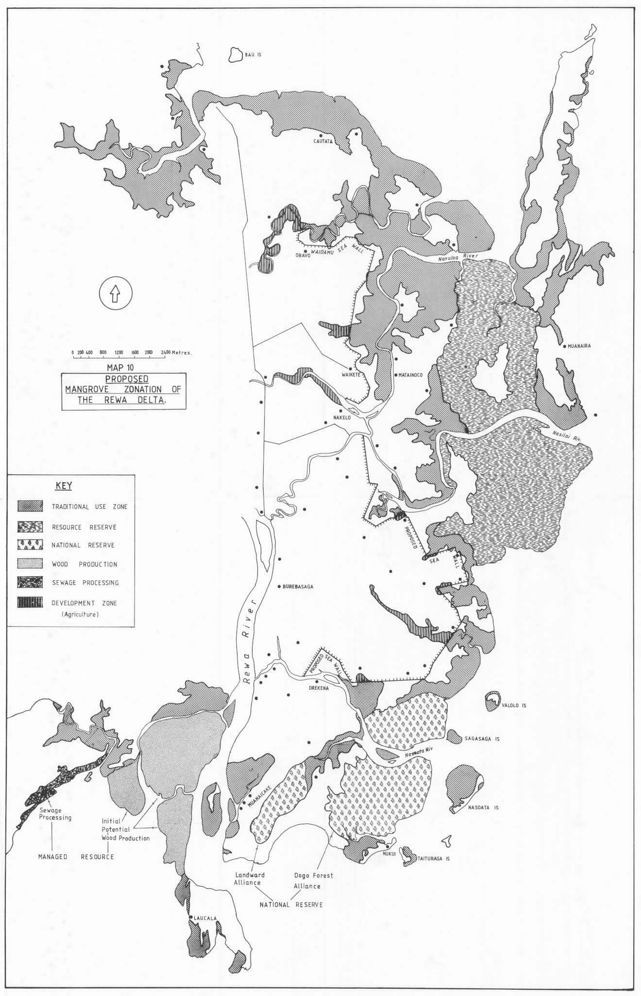
Mangrove Zonation in the Mangrove Management Plan for Fiji 1985/86.
Primary – Mangrove Reserve
- Resource Reserve
- National Reserve
Secondary – Managed Resource
- Traditional Use
- Wood Production
- Shoreline Protection
Tertiary – Development Zone
- Sewage Treatment
- Effluent Processing
- Urban Development
- Tourism Development
- Agriculture Development
Maps


A MANGROVE MANAGEMENT PLAN FOR FIJI (Phase 1)
- Phase 1 . Zonation requirements and a plan for the mangroves of the Ba, Labasa and Rewa Deltas.
- Prepared for The Mangrove Management Committee
- by Dick Watling
- A joint project of the Fiji Government and the South Pacific Commission
1. Introduction
Arising from Work shop held in Suva, February 1983 [Lal. 1983] the Cabinet of the Fiji Government endorsed the formation of Mangrove Management committee and directed that a Mangrove Management Plan be drawn up (CP(83)161 – Appendix 1. It was was considered a matter of urgency and pending its preparation there were to be restraints on further mangrove reclamation.
The project is overseen by the Fiji Government, through the Mangrove Management Committee
as a joint project between them and the South Pacific Regional Environmental Programme of the South Pacific Commission.
Dr Dick Watling was assigned as Mangrove Consultant from April – September 1985 with the following main terms of reference (Appendix 2),
- To formulate a set of criteria which will form the basis of a broad zonation philosophy in conjunction with the Mangrove Committee.
- To critically assess individual areas with the assistance and advice of governement officers.
In the context of the above and recognising a shortage of funds allocated to the project, the Mangrove Management Committee directed that Phase 1 of the Project be confined to the study of three priority areas – the Rewa, Ba and Labasa Deltas (LD 30/88).
2. Summary Of The Report
Fiji’s mangrove resource is estimated at 38, 543 ha , approximately 10% less than the present official figure. 2,457 ha or 6% of the original resource has been reclaimed.
The mangrove flora is comparatively simple being dominated by 3 species and a putative hybrid. The latter is of great scientific interest.
The 7 principles uses are categorised as:
- Traditional Uses
- Sustenance of the Capture fisheries
- Fuelwood Production
- Shoreline Protection
- Sewage Processing
- Preservation for science/education and aesthetics
- Conversion for alternative uses.
Mangroves have a national importance which is greater than that for individual or sectarian needs. Of major significance is its role in the sustenance of coastal fisheries, the ‘mangrove associated’ fishery being valued at over $20 million in 1983. The principal recipients being coastal subsistence consumers.
Major threats to the resource are poorly conceived and/or executed large-scale reclamations, piecemeal and ecologically unsound developments in peri-urban locations, pollution and spoil disposal from dredging for flood mitigation.
Mangrove reclamation is a valid development option when in the national interest. To ascertain this a broad socio-economic evaluation not a conventional financial analysis, is required.
A statement for National policy is proposed (p25) and a plan for mangrove management based on a zoning system is detailed. A hierarchical system is appropriate to ensure a degree of flexibility in management in those areas scheduled for Development or sustainable management whilst ensuring maximum protection for the majority of the resource. No restriction on traditional rights or utilisation of mangroves is proposed. At this stage the zoning system is intended as a planning guide but it requires endorsement at the highest level to be an effective aid.
The plan is applied to the mangroves of the Ba, Labasa and Rewa Deltas which constitute approximately one third of the national resource. They are major concentrations of highly productive mangroves which require a high level of protection. Zonation is based on consideration of the existing mangrove vegetation which is mapped into alliances reflecting probable differences in productivity, and the existing utilisation both traditional and contemporary, together with the national interest.
3. Mangroves In Fiji – An Assessment
3.1 Area of the Mangrove Resource
The area of Mangroves in Fiji has been variously reported as between 19,700 ha (Saenger et al 1983) anc 49,777 ha (Fiji Government as cited in Richmond anc Ackerman 1975). The present estimate is that 38,54: ha remain of an original resource of aproximately 41,000 ha with 2,457 ha or 64 converted to other uses. (Details in Appendix 3).
3.2 The Mangrove Vegetation
The Fijian mangrove vegetation is floristically simple. Three species and a putative hybrid of the family Rhizophoraceae overwhelmingly dominate the vegetation – Dogo Bruguiera gymnorrhizai Tiri Rhizophora stylosa; Tiri R.samoensisi Selala selala. Appendix 4 gives details of Principal and Common species, references and Fijian and, specific names.
3.3 The Legal and Management Framework
Following British Colonial tidal law, the Government recognises the Mean High Water Mark (MHWM) as the legal boundary between land and foreshore. All land above the MHWM belongs either to the Crown, Fijians as Native Land or private owners as Freehold Land. All foreshore below MHWM belongs to the Crown and no ownership of resources therein is recognised. However the Right to use the fishery resource belongs, where existence of traditional rights is recognised by the Native Fisheries Commission, to the Customary Fishing Rights Owners. This subject is still a matter of widespread concern and debate (see Anon 1979).
In 1933 all Mangroves were constituted Forest Reserve and were managed by the Forestry Department but in 1974 a cahinet Decision deproclaimed all Mangrove Reserves, (Legal Notice 52 of 1975), afterwhich all Mangroves came under the jurisdiction of -the Lands Survey Dept as an integral part of Foreshore . The same cabinet paper (CP 74(234)) instituted recompensation for loss of Fishing Rights. Prior to all reclamation approvals, an Independent Arbitrator hears submissions from all interested parties (Apolicant, Lands S Survey Dept., loon E Country Planning, Fisheries nept, Native Fisheries Commission) and then determines the level of compensation payable by the Applicant to the Customary Fishing Rights Owners. At present all compensation payments are hell by the Fijian Affairs Board as trustee for the Fishing Rights Owners. on application from the owners, the Board may nay out suns not exceeding $2,000. The balance nay be invested in consultation with the owners with a view to earning interest.
On reclamation of foreshore, the land remains Crown Property. (See Anon 1979; Lai 1983 for greater detail).
3.4 Fijian Fishing Fights
The Native Fisheries Commission was constituted in 1958 to determine the ownership of native customary fishing rights throughout Fiji.
The communal units Owning Fishing Rights which the Native Fisheries Commission recognises are either the Vanua or Yavusa.
Fijian Fishing Rights and the ‘ownarship’ of Mangroves are inter-related (Anon 1979) and whilst the legal aspect is clear, the issue has important hearings on mangrove management.
3.5 Uses, trends in use and economic considerations
Recently there has been increased awareness of the importance of mangroves but a continued reliance on conventional economic analyst. does not adequately evaluate the diverse services Mangroves provide, and so their true value continues to be under-rated by many policy makers.
Seven major functions of Mangroves in Fiji are identified and evaluated.
3.5.1 Traditional use
The majority of indigenous Fijians are coastal dwellers and a large proportion of these have access and utilise mangrove areas. It is net surprising therefore, that such communities have a profound utilitarian knowledge end dependence on mangroves. Research by Fisheries Department has shown that 83% of fish species caught in one mangrove area are recognised locally and consumed (Lal, et al 1983). Various crustaceans and molluscs, are, in addition important food items. Mangroves also provide firewood, building materials, ayes and medicinea (for a detailed list of Fijian uses are Pillai (in press) and world uses Prom 1982, Saengar et al 1989).
The direct and indirect products of mangroves .re free, continually supplied and self-sustaining, as Stich they are important determinants Of the quality of life for coastal communities.
Traditional use of mangroves will not diminish with improved living conditions and the development of coastal. communities. On the contrary, there will be an increased reliance on an indirect product – Coastal fisheries, not only for food requirements but mote specifically for income generation.
In many parts of Fiji tiri land is an important resource, it is an important means of sUstenance to the coastal people becaUse it provides both fish and crabs and is also an important source of firewood and building materials. In this regard its value and significance to the coastal communities is just as important as other lands
Par 43 – Report of the Committee Appointed to examine the nature of Fijian Fishing rights. 1979. Council of Chiefs, Lakeba, Lau 1978
3.5.2 Capture Fisheries
3.5.2.1 The association between mangrove. and capture fisheries.
The association and dependence of tropical coastal fisheries on mangroves is now we11 known but rarely fully appreciated by planners and policy-makers. A factor in this is the paucity of substantive data, much Still feller on correlation and inference but is nonetheless valid.
(See Appendix 5 for a summary of the function and values of the mangrove ecosystem.)
Mangrove associated fish and crustacea derive essential nutrition, either directly or indirectly from the primary or secondary productivity of the mangrove ecosystem during at least a portion of their life-cycle. Whilst ea a habitat mangroves provide essential safe breeding or nursery grounds’ Inshore and offshore (in this report defined as coastal waters away from mangroves; fisheries frequently harvest the same fish or crustacean species but at different stages of their life-cycle. Good Fijian examples of such species are the Damu Lutjanus argentimaculatus and the Great Barracuda, Sphyraena barracuda.
Research on the productivity of Fijian mangrove communities is limited but the results are directly comparable with the values published for overseas mangroves (Baines 1979; Gal et. al 1983). (Appendix 5 provides details).
Total plant biomass production in mangrove forests can exceed 20 tonnes per ha per year. Part of this production estimated at 3-4 tonnes per ha, largely in the form of leaf and twig litter is tidally exported into adjacent asters (Macintosh 1982). It is this considerable primary production which forms the oasis of the mangrove ecosystem’s crucial role in the sustenance of both on site and off site fisheries.
Limited research in Fiji has shown teat oven 606 of commercially important fish are mangrove associated at some stage of their life-cycle (data updated from Lai et al 19831. More rigorous research in Florida, USA revealed a figure of 80% and in eastern Australia 67%.
Elsewhere positive correlations have teen established between the area of mangroves and fisheries yields from adjacent waters (Macrae 1974; Martosubroto and Naamin 19771. Evidence of the direct effects of reclamation on capture fisheries are difficult to obtain as they are complicated by other factors.
ln the case of the Malacca straits, extensive mangrove reclamation for industrial purposes has been paralleled by a substantial drop in catches per Unit of fishing effort (Khoo 1976). Removal of mangroves can result in an offshore fisheries decline from 50-804 (Baines 1979).
Fiji’s inshore artisanal fisheries supply almost- the entire domestic consumption of fish {imported canned mackerel is tn. important exception), whilst the product of offshore fisheries, predominantly Tuna, is exported. Both fisheries (the Tuna fishery via Bait fish availability, are ultimately dependent upon a common resource and the- mangrove ecosystem that sustains that resource (Table 4a p40).
3.5.2.2 Economic considerations and trends.
Fiji’s artisanal fishery is in a state of rapid development. Between 1979 and 1984 the quantity of fish retailed domestically increased at an annual rate of 14.6%. This was a result of increased catching effort. Over the same period there was an annual increase of licensed fishermen of 9.3%. More significantly the number of licensed fishing launches and half-cabin boats (used by commercial as opposed to part-time fishermen) increased 24% annually. (calculated from Fisheries Department Statistics in Annual Reports)
This rate of increase cannot be sustained indefinitely, the level at which it can be sustainably maintained without overfishing will depend to a large part on the productivity (in situ and exported) of the mangrove ecosystem.
Whilst development of the artisanal fisheries for retail is a national priority, so to is the maintenance of the quality ‘ of life for coastal communities who depend on subsistence fishing for their protein requirements.
Retailed fish production still falls far short of the estimated capture for subsistence consumption – 49% in 1987. Whilst imports of fishery products (notably. canned mackerel) exceed retailed fish production by 318 (1984). Even at present for every two kilograms of fish caught and consumed here, just under one is imported. If national expectations are to be fulfilled without increased imports, it is clear that the fisheries base and mangroves which sustain it must be carefully preserved. Table 1 gives a financial breakdown of mangrove-associated fisheries in 1983.
3.5.3 Wood Production
3.5.3.1 Wood Production
In Fiji, as in many countries, mangrove is one of, if not the most highly prized fuelwood both for domestic and industrial consumption (Forestry Department Annual Reports). The wood burns well even when freshly cut, splits easily and is very heavy (specific gravity averages 0.9 for local species). It has a very high calorific value 4-4,300 kcal kg, and it leaves little ash. Mangrove wood is an exceptional source of Charcoal as it burns steadily giving off intense heat without sparking.
Formerly Mangroves were of major importance as a source of fuel-wood, Figure 1. In 1952, over 50,000 metre sq was harvested and processed by the Forestry Department who initiated working Plans based on sound management principles of sustained yield for the industry (see Marshall undated). However, the demand for fuelwood declined dramatically with the availability and convenience of imported fuel oil. The decline through the 1950’s and 1960’s stabilised at a fluctuating level around 5,000 m3 yr-1 after 1967, and precipitated the disappearance of a managed fuelwood industry. Today there are two active concessionaries in the Rewa Delta operating in c.10 he coups and other licensees, (Forestry Department).
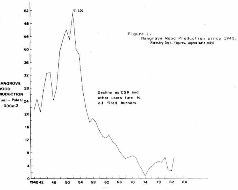
3.5.3.2 Trends and economic considerations
It is estimated that there are 18,000 ha of Mangrove which could be managed for fuelwood. Taking a conservative figure of 5m3 per ha per year as the annual increment, 90,000m3 of fuelwood could be harvested annually on a sustainable basis with a 30 year rotation, causing a minimal disruption to the productivity of the resource (Frith 1978). However, when the fisheries value of mangroves was considered in a economic analysis Johnston (19771 concluded that mangrove. do not compete favourably with inland firewood sources and are too valuable to use as fuel.
Th. average anneal growth rate of demand for fuelwood ie 3.3% per yr (Department of Energy Report 1982) but Mangrove is not considered a viable future source given the available wastewood and potential of inland firewood plantations (Director of Energy, Pers.Comm.1985).
Nonetheless the potential remains and should be considered in any economic analysis of the mangrove resource. At present Dogo retails fer approximately $25/m3 in bulk or up to $150/m3 when split and sold in small bundles. The annual, sustainable production of 90,000m3 be valued at between $2.25-13.5million.
3.5.4 Shoreline Protection
3.5.4.1 Function
Mangroves do not act as ‘land-builders’ as is often claimed, rather they are ‘stabilisers’ of sediments being naturally deposited by physical processes. They do provide considerable protection to areas on their landward side by ameliorating the erosive action of waves and currents.
They cannot prevent all flooding but do mitigate its effects. The coastal protection mangroves afford is roughly proportional to the width of the mangrove belt. Very narrow, fringing mangrove margins offer minimal protection, whilst extensive stands not only prevent wave damage but reduce such of the flooding damage by damping and holding floodwaters. (Odom et al 1982). Indonesia has recommended a 400m ‘green -belt’ to be maintained, (Burbridge and Koesoebiano 1982) whilst a minimum of 50-100m is recommended by Tang (1976) and Rabanal (1976) in Malaysia. Despite the very frequent occurrence of cyclones in Fiji, the current practice is to maintain a belt of 9-30m. Rabanal (1981) recommends a ‘Buffer Zone’ of 50-100m along rivers and 100-200m along the seacoast in Fiji.
Mangroves also protect coastal coral reefs from land erosion or disturbance. The stabilising, sediment trapping function of mangroves reduces sediment and silt loads which are a major cause of coral reef mortality. Thus they help maintain clear, coastal waters.
3.5.4.2 Economic considerations
The economic benefits of mangroves in shoreline protection cannot be estimated directly but must be considerable. The rehabilitation of ‘new’ seawalls in North-West Viti Levu following cyclones in 1983 and 1985 was $345,320 and $127,700 respectively (D&I figures).
3.5.4.3 Stability of the Mangrove area
A belief prevalent in Fiji, is that Mangroves are active land-builders, accreting substrate and hence ‘marching out into the sea’. This belief is used to argue in favour of reclamation, in that the area of mangroves is constantly increasing by growth at the seaward edge.
There is no evidence that mangroves have such an ability in Fiji or elsewhere and the belief is based on a misconception of the growth form of mangroves (see 3.5.4.1. and Carlton 1974).
A close comparison of aerial photographs of the 1950’s and 1978 of the Bo and Labasa deltas, reveals no detectable change in the seaward edge of the deltas. Changes in the course of the Ba river itself are significant, with apparently natural loss of mangroves in some areas and an increase in others.
In some areas on the southern coast of Viti Levu, colonisation by mangroves of recently deposited silt is taking place which must not be confused with possible accretion of Substrate. This silt is suspected to be the product of the landslides following Cyclone Meli in 1980.
3.5.5 Sewage Processing
Mangrove areas are proving extremely important to Fiji’s Sewerage and Sewage Treatment Programme. With the exception of Nausori, all of Fiji’s municipal sewerage plants are associated with Mangroves either as sites for the processing plants using oxidation ponds or for disposal of the effluent which may be directly into the Mangroves or in their vicinity.
Approximately 150 ha of Mangroves is presently or is planned for use in the Programme but – less than half of this will be converted for pond construction (Green Pers.Comm).
The use of Mangroves areas in the Programme is principally a cost saving factor – $2.3m were saved in the 8 ha Lautoka Plant by comparison with a conventional sewerage treatment plant (Green 1983).
Eutrophication caused by waste products of mans activities, of which treated sewage disposal is a major source is likely to increase concurrently with population growth and development. In Some places it has lately come to be appreciated as a major problem. Sewage discharged near reefs has killed coral in the U.S.Virgin Islands and in Hawaii (Salvat 1977; Banner 1974).
Whilst the disposal of sewage effluent after secondary treatment into Mangroves may be environmentally sound (but this has not been unequivocally demonstrated) there are dangers if domestic sewage is contaminated with industrial wastes and toxic bioaccumulation occurs. In addition, secondary sewage treatment does not remove most toxic wastes which are potentially harmful to both marine life and human consumer. of contaminated seafood, nor does it remove most viruses which are potentially harmful to swimmers (Westman 1974; Miller 1978).
Preservation for aesthetic, research, education or genetic resource requirements.
At present there is little appreciation in Fiji of Mangroves for their aesthetic appeal or for the need for preservation of some areas of mangroves for their genetic resource or habitat value to wildlife other than fish. A single 3ha Nature Reserve is being aquired at Samabula, Suva by the National Trust for Fiji.
However, hundreds of thousands of people visit Mangrove Parks in other parts of the world and with increasing education and awareness, there will be a similar demand in the future in Fiji, as well as reserves for scientific needs.
The flora of Fiji’s Mangroves is simple (Appendix 4) and so its genetic diversity is not great. However, the hybrid Rhizophora x selala is of great scientific interest and is found only in Fiji, Tonga and New Caledonia with Fiji holding the greatest resource of this hybrid. No terrestrial vertebrate is known to be confined to mangroves in Fiji.
No pecuniary value can be placed on the aesthetic and scientific functions of the Mangrove but some sectors value them highly. Whilst still small minorities these sectors will grow rapidly with increasing education and enviromental awareness, as they have done in other countries.
Mangroves are of great interest to many tourist and can be incorporated into tourist developments. Contrary to a widely held popular belief Mangroves do not harbour hordes of ‘sandflies’. These are in fact biting midges Culicoides sp and the common species in tropical and sub-tropical Australia have very restricted breeding requirements within the intertidal zone. Developments in Australia where Mangroves have been felled to rid the area of ‘sandflies’ have ironically created optimal breeding conditions for biting midges (Reye 1973, 1977).
3.5.7. Conversion for alternative uses.
3.5.7.1. Background
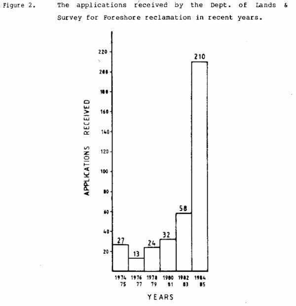
Approximately 2,500ha of mangroves have been converted or 6% of the original resource (Appendix 3). Much of this was reclaimed for cane cultivation by the CSR Company at the turn of the century but recently applications have increased dramatically (Fig. 2) and some large reclamations for agriculture have also been approved.
The general trend is large numbers of private applications for small area reclamation for residential and business purposes and large area government schemes for agriculture or industrial subdivisions.
Fijian mangroves are attractive to developers for several reasons – all cities and most towns are on or near the coast with easy access to mangroves, the latter are flat and the technology of conversion simple. More importantly mangroves being Crown Land are unalienated and negotiations for leases are straightforward, and until recently when Fishing Rights Compensation payments increased markedly, were cheap by comparison with adjacent land.
3.5.7.2. Agriculture
By far the greatest loss of Fiji’s mangroves has been conversion for agriculture. Yet at best, mangrove soils can be considered a marginal resource for the sustained development of agriculture. Flooding, salinity and the formation of acid sulphate soils are major management problems of mangrove reclamations in Fiji, Cyclones to which they are very vulnerable make sustained management in Fiji more precarious.
Too often the technical ease with which large areas of mangroves can ostensibly be reclaimed has diverted the attention of policymakers away from the very many failures and real difficulties involved in bringing mangrove soils into sustained productivity. The schemes at Raviravi, Penang, Navakai and even Dreketi are salutary examples of the problems.
Nonetheless Fiji is achieving some good sugar cane yields on reclaimed land, specifically those areas originally converted by CSR at the turn of the century. The recent rehabilitation of the Tabucola seawall and subsequent development of successful cane yields can not be taken as an example of productivity on recently reclaimed mangrove soils, During its many years under continual sugar production (since the turn of the century) the soils have undergone considerable pedogenesis.
Experimental results show some cane varieties can give acceptable yields on reclaimed soils (see Ellison & Sugrim (1983) for Raviravi).
The present view of FSC is that reclamation is economically viable but only on a large scale in excess of 50 ha using salt tolerant varieties of sugar cane. The present policy is to consolidate, increasing yields within the existing cane perimeter (Krishnamurthi, in litt.).
However, some mangrove areas specifically the Ba Delta have been considered in the past for cane land, and, will no doubt, be looked at in the future. The last such exercise was by the lands Department in 1973 who identified 5,241 ha. that could in part (55% was proposed) be reclaimed for agricultural use.
Rice is being grown on reclaimed mangrove land at Dreketi (150 ha). Acid sulphate soils and poor drainage have been major management problems.
In South East Asia there is considerable research into varieties suitable for mangrove soils and with Fiji’s position as a rice importer, it is believed that further large scale reclamations for rice cultivation may well be considered,
3.5.7.3. Aquaculture
A pilot penaeid shrimp project is underway on reclaimed land at Raviravi. If it proves commercially viable it will expand on already reclaimed land there. Further mangrove conversion is not envisaged.
It is unlikely that major Aquaculture development will be considered for Fiji Mangrove areas and specifically not for artisanal aquaculture. However, if any aquaculture development is to take place in the mangrove, then the first sites to survey and utilise if suitable, are the mudflats at the centre and landward edge of mangrove areas, as first advised by Rabanal (1981). Such mudflats are extensive in the mangroves of the Dry zone (6.6% of the combined total of the Ba and Labasa deltas). Utilising these sites first will have least affect on the overall productivity of the mangroves and the ponds will be protected by the surrounding mangroves.
3.5.7.4. Tourism
Mangrove reclamation for tourism development (c.200ha) is significant and given the expected and planned growth of the tourist industry, is likely to place increasing demands for conversion in the future.
Some tourist developments already appreciate the attraction and visitor interest in mangroves – Regent of Fiji, Vunaniu.
3.5.7.5. Urban
The location of all major urban areas in Fiji near to the coast and to mangroves has inevitably placed great demands on them for reclamation and this is increasing. Urban development and its associated pollution will always mean that adjacent mangroves are comparatively vulnerable, consequently their contribution to the national mangrove resource is diminished.
Conversion of some areas is necessary and the present pragmatic approach is appropriate. Applications and pressure on urban foreshore areas will increase dramatically unless ‘private reclamations are curbed in favour of socially oriented government schemes.
4. Mangrove Management In Fiji
4.1 The National significance of Mangroves
Except in subsistence communities, the traditional view has been that mangroves . are worthless unless reclaimed for alternative uses. This is essentially a ‘private viewpoint’ which originates in ignorance of the ecological and socio-economic value of mangroves together with the use of conventional economic analyses which do not adequately evaluate the diverse benefits mangroves provide.
Because of its ecological role and the nature of its products the mangrove will always be more valuable to society as a whole, than to individuals. A mangrove development programme viewed favourably from society’s (a socio-economic) perspective is not likely to be attractive from a private (or purely financial) viewpoint especially since each private development generally affects a very small fraction of the total resource and is therefore deemed to be inconsequential.
Since the total mangrove resource in Fiji is Crown (ie the Nation’s) Property and Government alone is responsible for its administrative, Government would be failing in its duty if any management or development programme was not in the national interest alone. Private developments, however convenient or financially attractive should only be entertained if they comply with stated national goals. This is both logical and practical and made more socially imperative by the existence of customary Fishing Rights. No matter how large compensation payments may be at present, they will be viewed as insignificant several decades hence.
It is clear that mangrove resource use conflicts require a strong National Policy which emphasises the socio-economic value of mangroves. Since Government is custodian, judge and often developer, the policy must be clearly stated and unequivocal.
4.2. Existing and potential threats
By comparison with many countries in South-east Asia, the threats to Fiji’s mangroves are slight and manageable. But the resource is very much smaller and thus more vulnerable.
The direct (in situ), legal uses of the mangrove today – crab fisheries, limited managed felling for fuelwood and traditional functions have negligible effect on the overall productivity of the resource. They are fully compatible with the major national function of the resource – the sustenance of capture fisheries .
The existing and potential threats to the resource are:
- lack of enforcement of regulations prohibiting unlicensed mangrove felling for commercial purposes. This in turn develops, if not actively encourages illegal squatting which is a serious but localised problem at present and is likely to increase.
- poorly executed (and perhaps conceived ) large-scale agricultural reclamations eg Raviravi.
lack of defined policy in peri-urban reclamations resulting in illogical piece-meal development, vulnerable to abuse. - a conflict in the ‘evolution’ of traditional uses with rural development of subsistence communities eg. illegal use of nets up creeks/rivers; overfishing as a result of commercial rather than subsistence needs; more widespread felling of
mangrove for non-traditional purposes. - pollution. Total lack of suitable regulations and enforcement of existing ones with no single authority responsible.
- estuarine dredging for flood mitigation; the siting of dredging spoil may cause fatal siltation in mangroves, and dredging may affect drainage patterns. Any major dredging works in mangrove areas should be preceeded by a thorough, environmental impact assessment.
The Plan
5.1. National Policy
The goal of National Policy for Mangroves should be explicitly stated:
Mangroves are an important national asset. Primarily as a resource base for capture fisheries. Secondarily as a renewable source of products which contribute significantly to the quality of life of associated coastal communities.
Recognising this.
The natural processes of the ecosystem should be preserved wherever possible thereby allowing the sustained harvesting of its renewable products and the preservation of future development options. Conversion activities should be minimised and permitted only in the national interest and after a detailed socio-economic comparison with the expected loss to the capture fisheries and other renewable uses.
5.2 Management considerations
5.2.1. Administration
The present procedure whereby all matters relating to Mangrove Management are reviewed by the Mangrove Management Committee with their recommendations then being considered for decision by the lands & Survey Dept. is appropriate. Although it is clear that eventually the Mangrove Management Committee will have to be incorporated into a wider Environmental Protection Agency which is an urgent national requirement. Decisions on Mangrove Management cannot realistically be made in isolation, as adjacent ecosystems eg Lagoons-coral reefs, intensive agriculture etc, have important bearings on mangrove management,
The present composition of the Committee lacks scientific expertise and this should be remedied but only if suitably qualified scientists, actively involved in mangrove research can be found.
The Ministry of Rural Development should be considered for representation in the Committee. Certainly it should be aware of the work of the Committee and informed of all plans.
The role of the Lands & Survey Dept. as both custodian and lessor of the Mangroves requires a very strict and even-balanced approach to management especially where conversion may be involved.
Conflicts of interest will be politically charged and will require careful, balanced consideration.
There have been some obvious and unfortunate breakdowns in Communications with developments affecting mangroves being undertaken without Lands & Survey Dept. being informed.
Good inter-departmental communication is essential.
The dereservation of Mangroves in 1974 meant that responsibility for Mangroves and the enforcement of regulations passed from the Forestry Department to the Lands Department. It is apparent that there has been little or no enforcement of regulations governing the cutting of Mangroves since that time. Illegal felling is locally serious and in part encourages illegal squatting which has developed into a national problem. Licenses for mangrove cutting are issued by the Forestry Department upon the consent of the Director of Lands & Survey. Administration and enforcement of regulations is the Forestry Department’s responsibility but it has no legal framework under which to prosecute offenders in such locations.
This whole area is in need of a review with the objectives of improving communications and strengthening the administration so that regulations are enforced. Licenses for fuelwood cutting should be available. However all felling should be carefully managed and this should be a Forestry Department responsibility.
5.2.2. Mangrove Management Plan – sequence of priorities
Preparation of the Plan should continue in the following order :
1) Identification of vulnerable mangrove locales (5.2.3.) ie periurban localities, tour ist development sites, and the preparation of a zoned map for each.
2) Reclamation guidelines. It is necessary for the Mangrove Management Committee, through the Lands Depart. as the issuing authority, to lay down certain requirements when reclamation permission is granted to protect remaining mangroves or as the basis for refusal.
Outside expertise from planners, engineers and ecologists will be required to assist in drawing up these guidelines.
The following is a provisional list of guidelines required:
- width of mangrove belt (Buffer) to be left for shoreline protection, etc
- seawalls, roads, riverbanks, buildings etc. seawall construction, roads – drainage requirements, prevention of siltation.
- waste disposal, drainage and pollution.
- siting of jetty’s.
- dredging access canals.
3) Preparation of zonation maps for remaining mangrove areas.
The following reviews are necessary:
1) A review of the Fishing Rights – Compensation procedure to investigate if there are any ways in which the process can be speeded up and be less expensive to carry out, and any possibilities of standardising payment with regard to. location/zonation.
2) A review of Mangrove Management for Fuelwood, the respective roles of Forestry and the Lands & Survey Dept. with regard to the issue of licenses; on site management and control; prosecution of offenders; revenue rates and beneficiaries.
5.2.3. Customary Fishing Rights
Compensation payments for customary Fishing Rights loss on reclamation have recently increased markedly and are now approximately $2,500/ha.
High compensation payments may well attract some Fishing Rights owners to ‘sell’ their Fishing Rights. It must be recognised that Fishing Rights Owners only hold the right to fish in situ, whilst Mangroves also serve a national function both in situ and off site. Agreement for reclamation or schemes initiated by Customary Fishing Rights Owners, where compensation is waived, should not be considered as a license for reclamation to proceed. The National interest should prevail. Conflicts of interest occur and are likely to increase.
For example two recent and possibly inappropriate decisions are cited.
At the Wairabetia reclamation Tribunal, it was claimed that much of the Customary Fishing Rights Owners Mangrove was already polluted (Agriculture Tribunal, FR 4/85). The inference being that a greater value should be placed on the mangroves scheduled for reclamation.
In such cases the valid question is not as to the level of compensation but whether to permit reclamation at all, in both the National and the long term interest of the Fishing Rights owners.
At Votua, Ba 5ha of Mangroves are being reclaimed for agriculture. The scheme was initiated by the Fishing Rights owners and will be developed by them. Considering the experience of the Government reclamation at nearby Raviravi, the efficacy of such a community development is questionable. Further consideration would have revealed that the Mangroves are probably some of the most productive in the Ba Delta, and that the Benefit Ratio (Area of land brought into cultivation: area of Mangrove lost) is effectively i. (Contrast the adjacent Sarava scheme where the Benefit Ratio is over 10 – 296 ha protected for 29 ha of Mangrove mostly mudflat and stunted Tiri, lost).
Waiving of the compensation-payment at Votua (n.b. $110,000 – 49ha at Wairabetia) may have been a major factor in the reclamation approval. Undoubtedly the national interest would have been better served in conserving these productive mangroves for the capture fisheries benefits.
5.2.4. Zonation
5.2.4.1. Background
Mangrove distribution with in Fiji is not uniform (Map 1) and the mangrove vegetation itself varies from one locality to another. This is most marked between the mangroves of the dry, leeward coasts and those of the wet, windward coastlines. Recognising this and since the benefits that mangroves provide are received either in situ or in adjacent or offshore waters, management of the mangrove resource should be directed at a local, rather than a broad national level.
Initially, Fiji’s coastlines should be divided into management “locales’ and a suitable framework already exists in the 1:500,000 series, but demarcation between locales should be by natural features approximately defined by the 1:50,000 grid. In this context the Ba, Labasa and Rewa Delta? would eaxh comprise a single management locale. The goal should be to balance management activities especially conversion between locales, thus preventing localised disruption to the resource becoming too severe.
The mangrove vegetation should be classified in alliances. For the present the alliances are characterised by an assessment of their standing biomass which is considered to be the best gross estimate of their productivity. A conventional vegetation map would be too detailed and of limited management use. The alliances are intended as practical management units which are sufficiently broad and therefore few ‘in number to enable any mangrove area to be character ised and therefore be compared with any other.
When prepararing a zonation plan, the alliances should provide the basic mapping unit, on which a consideration of potential and existing uses and threats are super imposed. At present the alliances are subjectively characterised, empirical data on their productivity status is urgently needed.
A hierarchial designation of zones is proposed so as to allow a degree of flexibility within the ‘Managed’ and Development’ scheduled zones whilst affording maximum protection for the majority of the resource. Table 3 illustrates a Use-Compatability Matrix for the proposed zones.
It must be emphasised that the scientific data base on which this suggested zonation system is formulated is very limited and in its present form is a guideline which will require refining. Any development application whether for conversion or managed harvesting of a renewable resource should still be considered on its own merits with reference to National Policy.

5.2.4.2. Primary Designation – Mangrove Reserves
5.2.4.2. A Resource Reserve
Mangrove areas identified as being of primary importance specifically in the sustenance of the capture fisheries, but for other reasons too which would become known on completion of detailed research. Areas selected on the basis of suspected high productivity or diversity, generally rather little used and with limited access. The objective is to prevent any activities which might deleteriously affect the resource. This should include appropriate zoning of adjacent land and coastal areas to ensure the integrity of the area.
5.2.4.2.B National Reserve
Areas of major scientific, educational or aesthetic interest. The objective is to provide full protection for the areas.
5.2.4.3. Secondary Designation – Managed Resource Areas.
5.2.4.3.A. Traditional Use Zone
Mangrove areas which are subject to continual use and are required for the sustainable subsistence needs of Rural communities. In some localities Traditional use zones will be effective ‘Buffer zones’ around Resource Reserves.
5.2.4.3.B. Wood Production zone
Mangrove areas which have potential either through location on species composition, to be managed for :commercial timber or firewood. Exploitation should be managed by the Forestry Department and based on specific Working/Management Plans. Potential Wood Production zones should be regarded as Resource Reserve until they are managed for wood production.
5.2.4.3.C. Shoreline Protection zone
Mangrove areas which are clearly required for the protection of adjacent land – roads, seawalls, agricultural land; or adjacent offshore reefs from inland erosion causing silt or pollutant dispersal.
Planting of Mangroves should be carried out in vulnerable areas which have lost their mangrove flora.
5.2.4.4. Tertiary Designation – Development zones
5.2.4.4.A. Sewage Processing
There are two components to the Mangrove areas required for sewage processing, a relatively small site converted during the construction of the oxidation ponds and a larger dispersed area which is likely to receive the effluent. Monitoring for possible health hazards in the latter area is essential.
5.2.4.4.B. Urban
Areas primarily destined for conversion in peri-urban environs. Conversion should not be seen as the only development option. Designation of some mangrove areas as ‘open space’ – to enhance the waterfront, for local coastal protection or for aesthetic and educational purposes would be important. However, the zones should not be considered as essential to the national resource and their destiny should to a large part be controlled by the plans of urban authorities. The latter should appreciate or be made aware of the aesthetic, conservation function in addition to the conversion option,
5.2.4.4.C. Tourism
The development of the tourist industry is a national priority and as such mangrove areas will be considered for conversion if associated with development sites. Tour ist operators are increasingly aware of the value of mangroves as tourist attractions and this should be encouraged in the preliminary planning period…
5.2.4.4. Agriculture
Areas which should be converted for agricultural use. Projects involving large scale clearance of mangroves will always be considered on their own merits and decisions made at the highest level. They cannot be zoned for in advance. At present only those areas cut off from salt water by sea wall construction are zoned for agriculture. Mangroves should not be clear-felled – along the banks of creeks in such areas, as they will survive for many years in fresh water and will help prevent bank erosion.
6. THE MANGROVES OF THE BA, LABASA AND REWA DELTA – A ZONATION PLAN.
6.1 Introduction
The Ba, Labasa and Rewa Deltas support some of the largest concentrations of the nations mangroves, a combined total of 10,683 ha or 28% of the national resource. Be ing deltas of significant river systems they have a continual supply of nutrient rich freshwater, a major factor in their overall productivity which enables each to sustain an important and distinct capture fisheries. They constitute the major and most important concentrated
mangrove resource in the country.
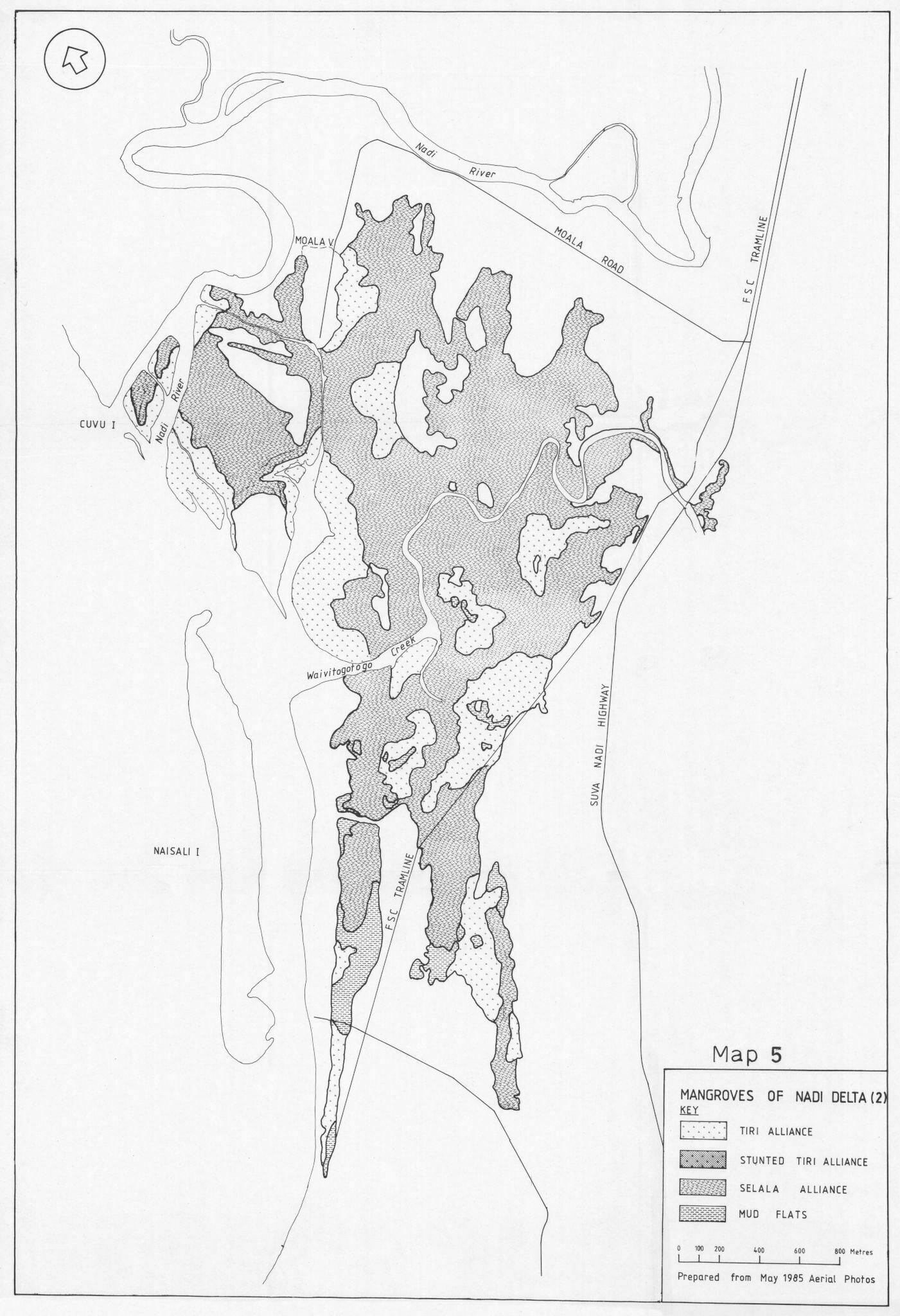
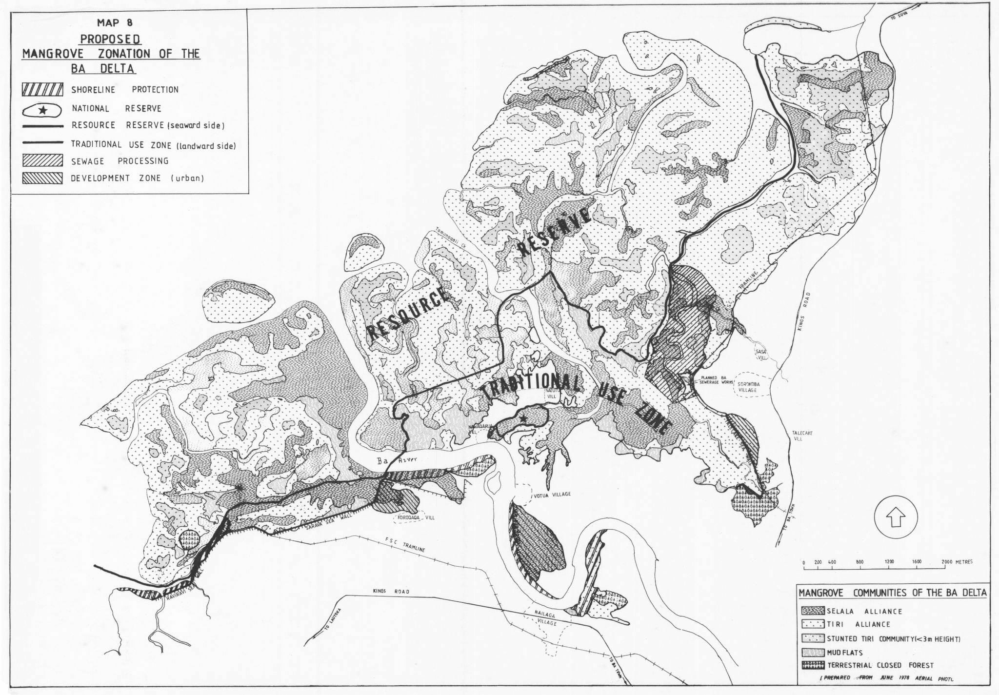
6.2 The Ba Delta
The Ba Delta supports the largest contiguous stand of mangroves in Fiji, some 3,995 ha of which 281 ha is mudflat, on a classical alluvial fan.
The watercatchment of the Ba river is approximately 940 km’ or about 10% of the area of Viti Levu, all of it in the dry, leeward zone. The total volume of water discharged is in the order of 1,636 million in 1 yr (Kammer, in litt.). The delta receives an average annual rainfall of 1,905mm and experiences a pronounced dry winter. The dry, seasonal climate has a profound effect on the mangrove vegetation which is readily observable and has important management implications. The more elevated and less well-drained mangrove areas which are poorly: flushed by high tides become hypersaline as a result of the high evaporation rates and insufficient washing by rainfall. Such areas also receive less: nutrients with the result that they become less productive mangrove habitats.
Large areas of ‘stunted’ Tiri are evidence of this and where the salinity level increases above which even mangroves can tolerate, bare mudflats result. These bare hyper-saline mudflats have negligible productivity, but they do support a limited fauna and flora and do have a “habitat’ value for fish and crustacea during high tides. Saline mudflats are a characteristic feature of dry zone mangroves, but victually absent from the wet zone.
6.2.1. Mangrove flora of the. Ba Delta
Floristically the Ba Mangrove community is the least diverse of the three deltas. Notably there is a complete absence of a Dogo dominated forest.
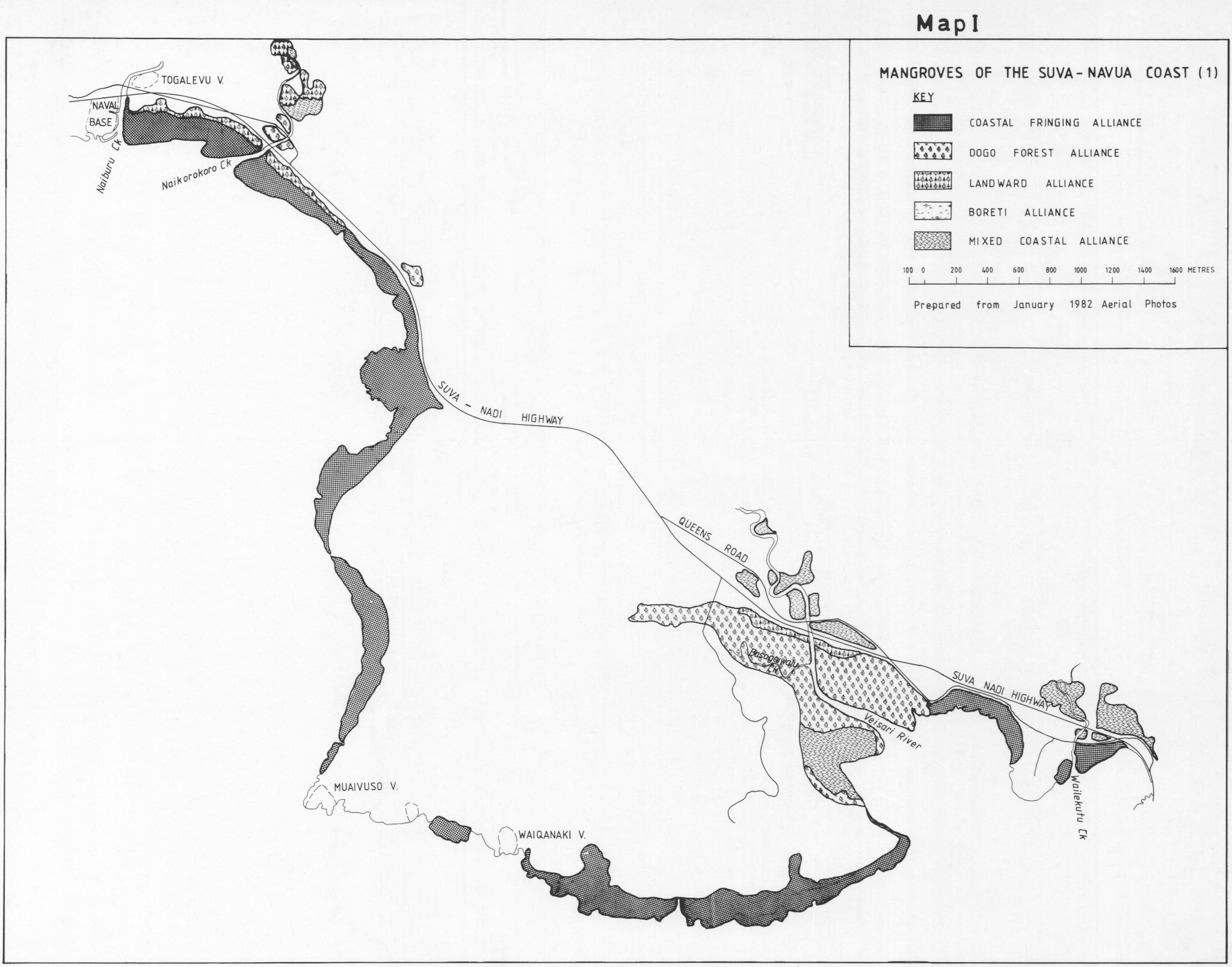
TWO major mangrove alliances have been distinguished both of which contain one or more distinct associations. (See Appendix 8, Map 1).
6.2.1.1. The Tiri Alliance
Rhizophora stylosa forms an almost pure closed shrub forest on the extensive less-well drained flats behind the river and creek banks. The canopy height varies dependent on location. The least well drained areas often surrounding or adjacent to hypersaline mudflats are stunted with a canopy height of less than 2m. Elsewhere the canopy height increases to 5m. In some localities R. stylosa is mixed with and occasionally replaced by R..samoensis.
On the seaward banks, R.stylosa shields ill-formed levees supporting R.samoensis, Selala, is found in a distinct association which is similar to but less well developed than the Seaward Alliance of the Rewa Delta (6.4.1.1). A thin belt of R.stylosa. Some small Dogo and occasional Dabi with a taller canopy height of upto 8m. In some localities Selala appears and can dominate assuming the character of the Selala Alliance. .
Another distinct association of the Tiri Alliance (which could be considered another Alliance) is found along or near the main river bank in upstream locations. This is dominated by vigorous Rosamoensis with a canopy height of 5-7m, occasionally forming pure stands but more frequently as a mixed open forest with some R.stylosa but principally emergent Selala. Landward species such as Sinu, Tavola and Ivi appear as the association merges into a terrestrial forest dominated by the Rain Tree Samanea saman on poorly drained soils. The area of the Tiri Alliance is approximately 2,472 ha or 62% of the total.
6.2.1.2. The Selala Alliance
This is an open forest alliance dominated by the Selala hybrid. It is found to varying extents on almost all the river and creek banks and associated watercourse levees, Dogo and Dabi occur infrequently with either R.stylosa_but most commonly R.samoensis. The canopy is very uneven and varies between 6-12m which is a reflection on the vegetative vigour of Selala and its emergent growth form. The area is approximately 1,243 ha or 31% of the total.
6.2.2. Soils of the Ba Mangroves
Map 4 (Appendix 8) is a soil map of the Ba Delta. All the soils a-f are similar and were previously termed ‘saline soils of the Marine Marsh’ (Twyford and Wright 1965). They can best be distinguished on the basis of different drainage conditions, imperfectly drained – a, poorly drained – b, c, d and very poorly drained – e, E. Drainage is the main causal agent of pedogenesis (soil development) in the mangrove environment. Detailed physico-chemical data is available for all soils (v. Seru -Land use, Ministry of Primary Industries)
In terms of use potential these soils are best regarded as “problem soils” mainly due to salinity from seawater, difficulty of drainage, high acidity and sometimes high organic matter levels. Such soils are costly to improve.
6.2.3. Mangrove utilisation in the Ba Delta
The Ba Delta mangroves sustains one of the most important offshore fisheries. Figures for produce marketed at Ba (Table 4b) in no way relate to the real production as much of the produce is retailed in other outlets and other urban areas, especially Lautoka Market.
The Customary Fishing Rights Holders for the entire Ba Delta are 3 Yavusa all resident in votua village which had a population of 420 in 1976. These Yavusa have a record of vigorous protection of their Fishing Rights. 8 other vilages with a total population of 1,654 are located around the delta and utilise its products extensively, and to a lesser degree do the non-Fijian farming community.


There is no legal commerical Wood production in the delta but illegal cutting for sale is taking place. In some highly visible sites this illegal felling is causing severe destruction.
Hassal (1984) reports recent illegal reclamation of the Mangrove edge. This appears to be based on a mis-interpretation of data maps and aerial photographs used. There has been negligible reclamation outside the Raviravi project but a substantial loss of closed terrestrial forest on the landward edge of the mangroves.
Comparison of 1954 and 1978 aerial photographs reveal substantial changes to the Mangrove vegetation along the main river banks of the Ba river with considerable erosion and deposition. The comparison also reveals changes in the extent of hypersaline mudflats, whilst constant in location their size changes as a result of recession or invasion of Tiri. The trend at present points to a reduction in size.
Three sea walls on the delta have recently been constructed. Loss of mangroves including extensive mudflats was 159 ha with 466 ha of agricultural land being protected and thus brought into production.
The Ba Delta has long been identified as a site for large scale reclamation for agriculture (see Baines 1979). In 1973 the Lands Department identified 2,367.5 ha (or 55% of the gross Delta area) as potential for reclamation. At present FSC have no plans for expanding the cane perimeter and are consolidating to improve yields. A Ba reclamation scheme was considered as recently as 1982 but rejected.
It is clear, however, that FSC do have the capability of producing acceptable cane yields on reclaimed soils, so the option will always remain.
6.2.4 Specific Management Considerations
- The Mangroves of the Ba Delta sustain a major national fisheries and primary importance should be given to this function
- Any large scale conversion for agriculture should only be considered after a very detailed socio-economic review of the Raviravi reclamation has been undertaken, Why and at what overall cost is it still idle 14 years after reclamation ?
- Further peripheral reclamation might be considered closing the boundary with sea walls. This serves the important function of delineating the mangrove/foreshore boundary. If such schemes are proposed an important consideration is the ratio of land protected by the sea wall (ie brought into cultivation) to mangrove lost. The ratio for the Sarava sea wall was 1:10 with little mangrove as opposed to mudflat reclaimed. In strong contrast – the Votua sea wall ratio was 1:1 with over 50 ha of very productive Mangrove reclaimed.
- No industrial or other urban satellite from Ba Town including municipal rubbish dumps should be considered. None exist at present and if situated at the top of the delta, any pollution problems would be potentially ser ious. The existing integrity of the delta from Ba town with the exception of the sewerage work, should be maintained.
- Any dredging works of the Ba River should be preceeded by a thorough impact assessment.
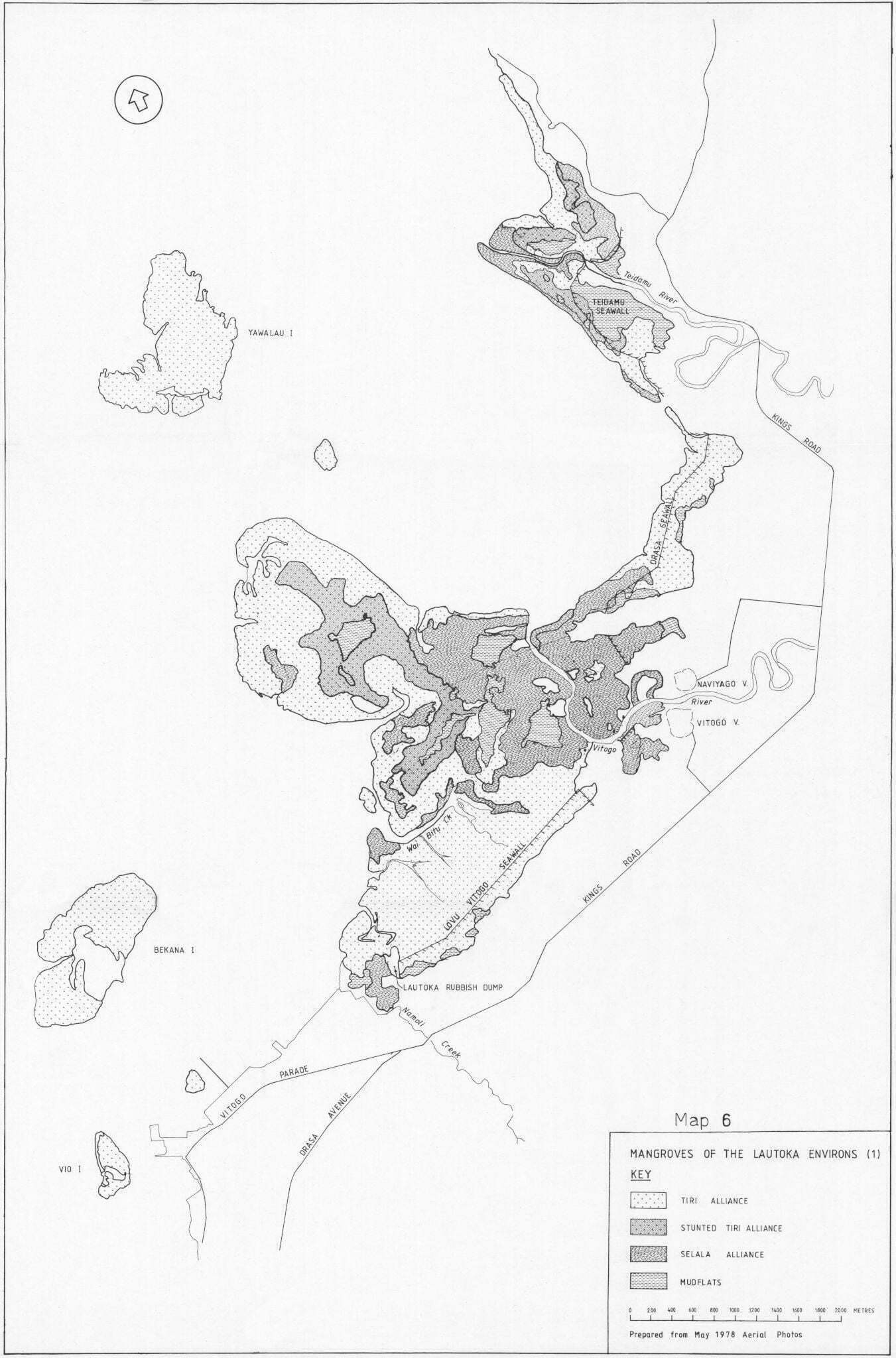
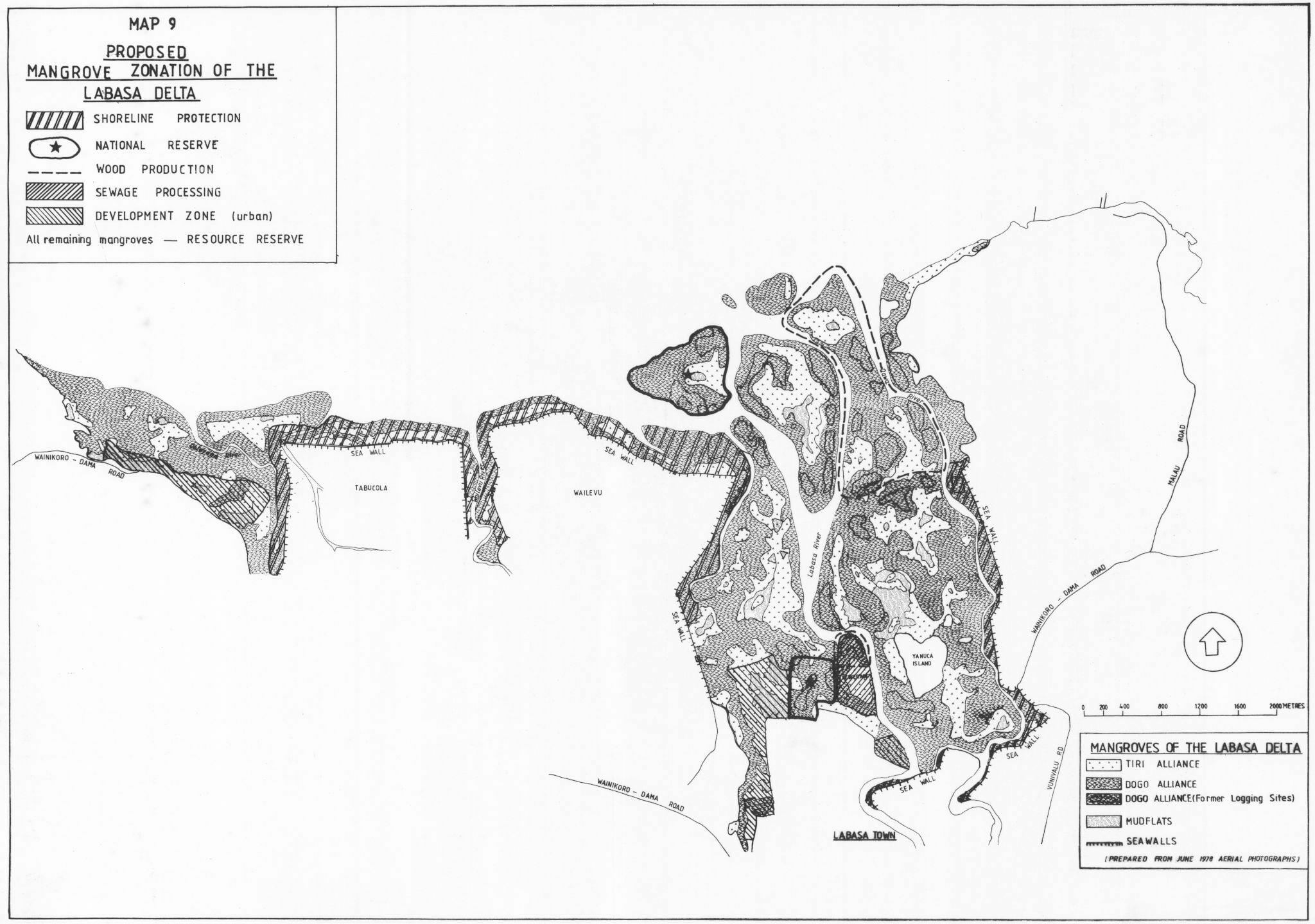
6.3. The Labasa Delta
The Labasa Delta lies in the Leeward ‘dry’ zone of Vanua Levy, receiving a mean annual rainfall of 230 9mm (1910-1980 annual av.) and experiences a distinct dry season which is less marked than at Ba. The delta is an alluvial fan from three river sources, the Labasa, Qawa and wailevu which dra in the fertile Labasa plains and adjacent foothills, an area of approximately 460 km. The combined annual discharge of the rivers is of the order of 1065 million mo.y? (Kammer in litt) area
The total mangrove area is approximately 1,558 ha today but was formerly more extensive (6.3.3.1).
6.3.1. Mangrove Flora of the Labasa Delta
The Mangroves of the Labasa Delta are floristically more diverse and the greater biomass per unit area indicates greater productivity than those of the Ba Delta. The seasonal, dry climate has resulted in the characteristic formation of hyper-saline mudflats with adjacent stunted Tiri in the less well-drained areas.
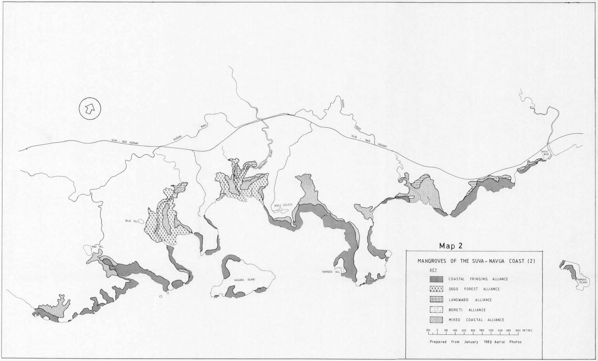
Two alliances are distinguished (Map 2, Appendix: 8)
6.3.1.1. The Tiri Alliance
A closed shrub forest of the poorly drained flats well behind the river banks and the seaward edge, generally with hyper-saline mudflats at their centre.
R.samoensis dominates the association forming pure stands in most places especially towards the centre. Dogo and Selala are increasingly found at the outer edge where the Alliance’ merges with the Dogo Alliance. The canopy height declines from 5-8 m at the periphery to 1-2.5m near the mudflats. The area of the Tiri Alliance is approximately 404 ha r 25.9% of the mangrove area.
6.3.1.2. The Dogo Alliance
Dogo dominates this Alliance and in many areas forms puce stands of 10-15mm canopy height. Selala and R.samoensis either separately or combined forma distinct, vigorous association of limited extent along the river and creek banks, canopy heights may reach 15. They are more in evidence in a mixed association. with Dogo on the seaward fringing stands off Wailevu and Tabucola. R.stylosa forms a fringing belt along many parts of the seaward edge but is occasionally displaced by pure R.samoensis. Conversely R.stylosa occasionally replaces R.samoensis in its more usual river bank locations. The more landward species Dabi, Sagali at Sinu are locally common especially at the head of the delta where there are some small pockets of typically terrestrial vegetation. The area of this Alliance is approximately 2749 ha or 68.6% of the total.
6.3.2 Soils of the Labasa Mangroves
There is no soil map yet prepared for the labasa Mangroves but they have been investigated and are of the same types as those found in the Ba Mangroves 16.2.2), Twyford and Wright (1965).
6.3.3. Uses of the Labasa Delta Mangroves
6.3.3.1. Historical
There has been major reclamation of Labasa Mangroves. At the turn of the century the CSR Company built three major sea walls of Wailevu, Tabucola and Nasea. Considerable areas of mangrove must have been cleared. Baines (1979) quotes 2,713 ha and Lal (1983a) 2,250 ha but neither attribute their source of information.
D&I calculate that 1,292 ha of land is protected (ie lies below the 2m contour line) by the three sea walls (Ernest 1983 and confirmed by Patel, D&I pers comm 1985). An examination of Orthophotoma ps (1:5,000) of the adjacent Tabia estuary as well as the Lautoka and Rewa Mangrove areas indicates that no substantial, if any, mangrove vegetation is found above the 2m contour and so 1,292 ha is an absolute maximum figure for the area of mangrove reclaimed. A more reasonable estimate might be 650 ha.
This constitutes approximately 30% of the original resource which is a significant loss.
Examination of 1954 and 1967 aerial photographs reveal evidence of extensive felling for Dogo fuelwood. Initially scattered areas were almost clear felled, but this practice was replaced by managed coups with regularly spaced seed trees being left. No production records are available, but bakeries in Labasa and the CSR crushing mill are known to have been the major consumers of fuelwood. It is probable that production mirrored the national trends (Fig 1) with CSR converting to oil burning equipment from 1955.
Regeneration of Dogo has, in most instances been excellent but there are visible differences in canopy height and stand structure; subjective observations indicate a greater frequency of densely spaced th in-trunked Dogo in some cut over stands when compared with unfelled stands. In some cut over stands there appears to be an increased frequency of Selala regeneration with a more disrupted canopy
6.3.3.2. Existing Utilisation.
The customary Fishing Rights owners of the Labasa Delta east of the Wailevu River is the Vanua of Labasa whose 20 Yavusa live in 7 villages with a population of approximately 500 (1976). “The Vanua of Wailevu comprising 6 Yavusa of 408 people own the Traditional Fishing Rights of the mangroves to the west of the Wailevu River. Neither Vanua’s Fishing Rights areas extend far offshore, they are comparatively limited in extent.
Labasa is now a major and the fastest growing fish supply centre in the country, much of the produce being retailed in Viti Levu; as with Ba, the market figures are no indication of true production (Table 4b 240). Labasa is particularly well known as a rich source for the Mangrove dependent Qari.
Labasa Town is the rapidly growing capital of Vanua Levu and has a shortage of available land for development. Inevitably mangrove reclamations have been considered and to date nearly 60 ha have been converted or approval granted to development requirements close to the town, Included in this is 24 ha for the Sewerage Oxidation ponds much of which is for effluent disposal and will not be cleared.
6.3.4 Specific Management Considerations
The Mangroves of the Labasa Delta form an important productive unit which contribute greatly to the
rapidly growing fisheries centred at Labasa.
The Delta has already been extensively modified by reclamation for agriculture. Further major losses
should not be considered,
Any pollution from Labasa Town and the FSC Mill are both discharged at the head of the delta, all of which is therefore exposed and vulnerable if pollution is not controlled. Fish kills as a result of Mill discharge are of almost annual occurrence.
All heavy industry should be cited at the Caloyago Industrial site and not at Vakamasuasua.
The Town Council Rubbish Tip is in serious need of better management.
Any dredging work within the Labasa Delta should be preceeded by a thorough impact assessment.
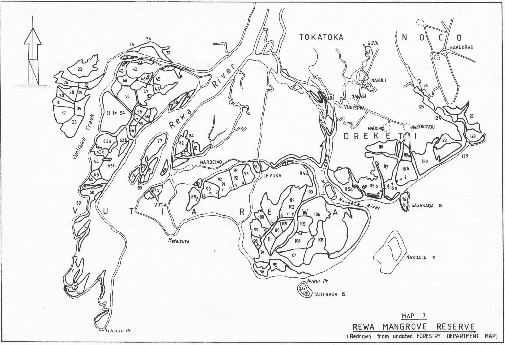
6.4. The Rewa Delta
The Rewa River drains approximately 2,980 km or about one third of Viti Levu and discharges of the order of 7,897 million most of water a year. It has been estimated that perhaps 1600 tonnes of suspended sediment are transported to the month of the river each year (Kamner, in Litt). This alluvium has formed Fiji’s most fertile and productive delta with approximately 5,130 ha of mangrove.
6.4.1. Mangrove Flora of the Rewa Delta
It is probable that the Rewa Delta would be more extensive if it was not situated on the windward side of Viti Levu and so exposed to the continuous, erosive action of wind and wave. One consequence is that much of the delta mangrove is in backwater locations. These Mangrove communities are the most diverse in the country and the high, regular rainfall which the delta receives prevents hyper-saline mudflats forming.
There are areas of shrub Tiri, but they are limited by comparison with those of the leeward mangrove stands. The landward vegetation element is strong and in many locations there is a clinal integradation of terrestrial closed forest into the mangroves.
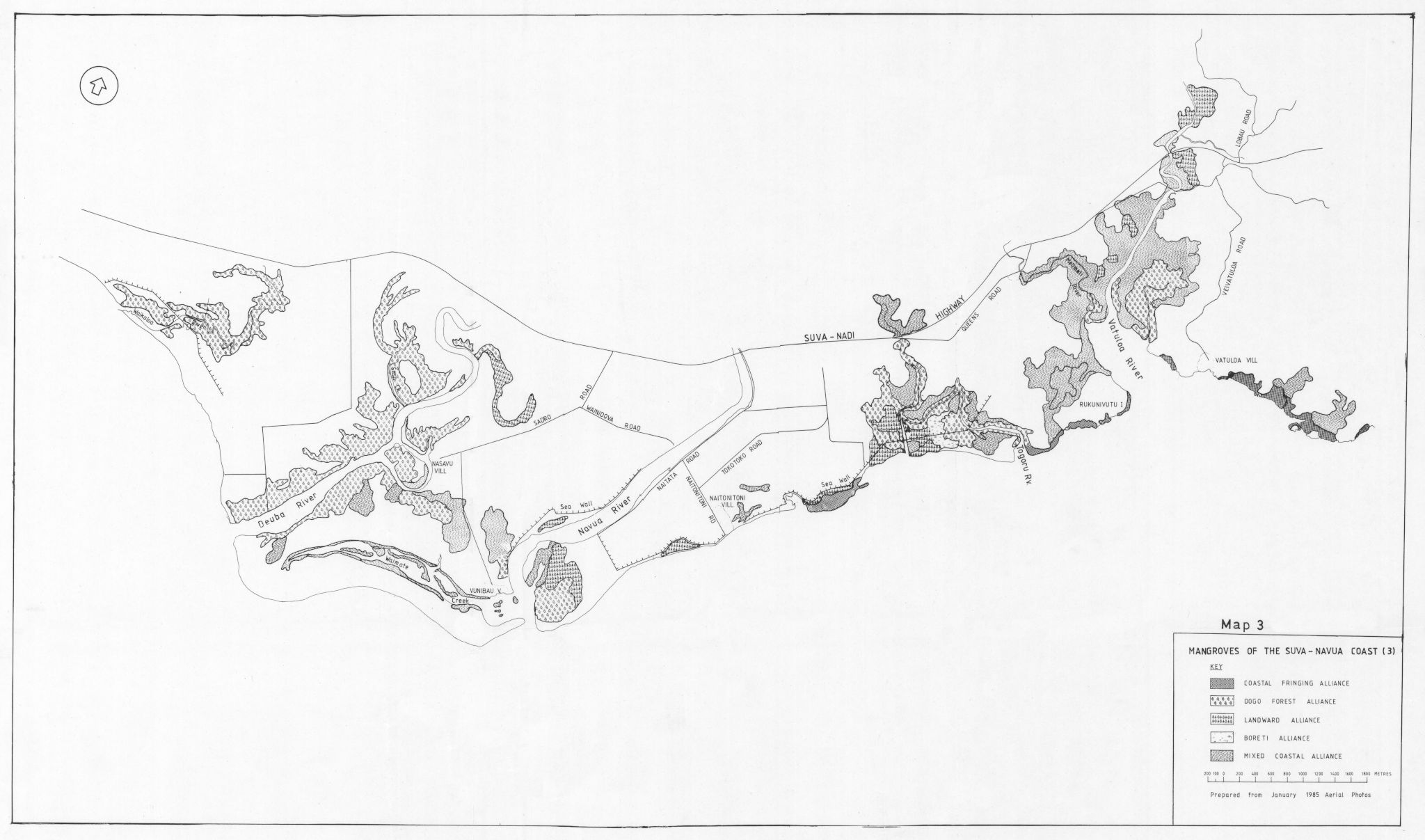
Six alliances have been distinguished,
6.4.1.1. The Seaward Alliance
This alliance is a mixed fringing forest, found predominantly on the more exposed seaward banks but also extending up some of the larger creeks and rivers. B.stylosa (2.4m canopy height) often forms a single belt on the seaward edge with taller trees
abruptly behind mixed with Selala, Dogo and R.samoens is having a closed canopy height of 5-121. Leves in these situations support in addition Dabi, Sinu and other landward species including coconut. Area – 248.8 ha, 4.98 of the total area.
6.4.1.2. The Rewa Tiri Alliance
An extensive formation of the northern Rewa Delta consisting of R.samoensis dominated shrub forest with a canopy height of 1 – 4m. Stunted Dogo, Dabi and R.stylosa are commonly present. A distinct association of this alliance is a fringing forest of predominantly R.samoensis in the less exposed coastal areas and along river banks, the closed canopy var ies between 5-9m. Area – 741.9 ha, 14.5% of the total areas.
6.4.1.3. Dogo Forest
This is an uniform closed forest of almost pure Dogo with a canopy height of 9-15m; some well developed stands are 18m or more in height. Within the forest occasional Selala occur with Dabi and Sagali. Both the Landward Alliance and mixed Alliance merge indistinctly into the Dogo Forest in many locations. Area – 1820 ha, 35.6% of the mangrove area.
6.4.1.4 Mixed Alliance
The Mixed Alliance is a heterogenous open forest of variable and mixed composition with an uneven canopy height of 5-15m. Dogo and Selala are the dominant species, sometimes forming small discrete stands. R. samoensis occurs commonly and also forms limited pure stands, occasionally stunted. The presence of Dabi, Saqali, Sinu and landward vegetation varies greatly with location. Small areas of Boreti fern are included in this alliance. Acea – 1491 ha, 29.1% of the mangrove area.
6.4.1.5. Landward Alliance
A heterogenous closed forest of mixed composition forming the floristically most diverse mangrove alliance Found only in the least exposed situations, the presence of an extensive epiphytic and climbing flora indicates that the alliance is stable, well drained and well protected from storm damage.
The most common tree species are Dabi, Dogo and Sinu with a canopy of 10-12m. R. Samoens is and Selala occur more rarely and on creek banks. Other common trees are Terminalia littoralis, Heritiera littoralis, -Inocarpus fragiferus. Ficus obliqua, Hibiscus tiliaceus, Pandanus pyroformis and Cocos nucifera. Area – 645.4 ha, 12.6% of the mangrove area.
6.4.1.6. Boreti Alliance
Some large areas of poorly drained flats support a dense growth of Acrostichum aureum the Leather Fern or Boreti, Area – 182.4 ha, 3.6% of the mangrove area.
6.4.2. The Soils of the Rewa Mangroves
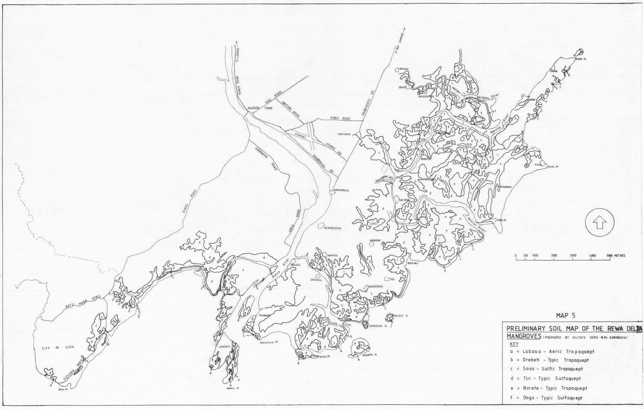
Map 5 (Appendix 8) is a soil map of the Rewa Mangroves. The soil types are the same problem soils as described in 6.2.2. Roy & Richmond (in prep) maps the Recent (Holocene) geology of the Rewa Delta.
6.4.3. Historic and existing utilisation
In pre-European contact times, the Rewa Delta is believed to have supported one of the densest populations in the Pacific. A population which had evolved in close association with the mangroves and developed a mutual indirect dependence.
The population today is smaller but is still by a far the largest mangrove associated community. In 1976, there were nearly 9,000 Fijians living in over 100 village communities dispersed through the delta. The structure of Customary Fishing Rights ownership is well established between 5 Vanua and 4 Yavusa.
The Delta sustains an important artisanal fishery both in situ and offshore which supplies not only the delta communities but much of the needs of greater Suva with its approximately 70,000 inhabitants. Table 4a (240) gives production figures for fish and crustacea at Suva and Nausor i markets. Production figures at Suva market have declined from 342 to 52 tonnes from 1976 to 1984, the majority of produce is now retailed through other outlets.
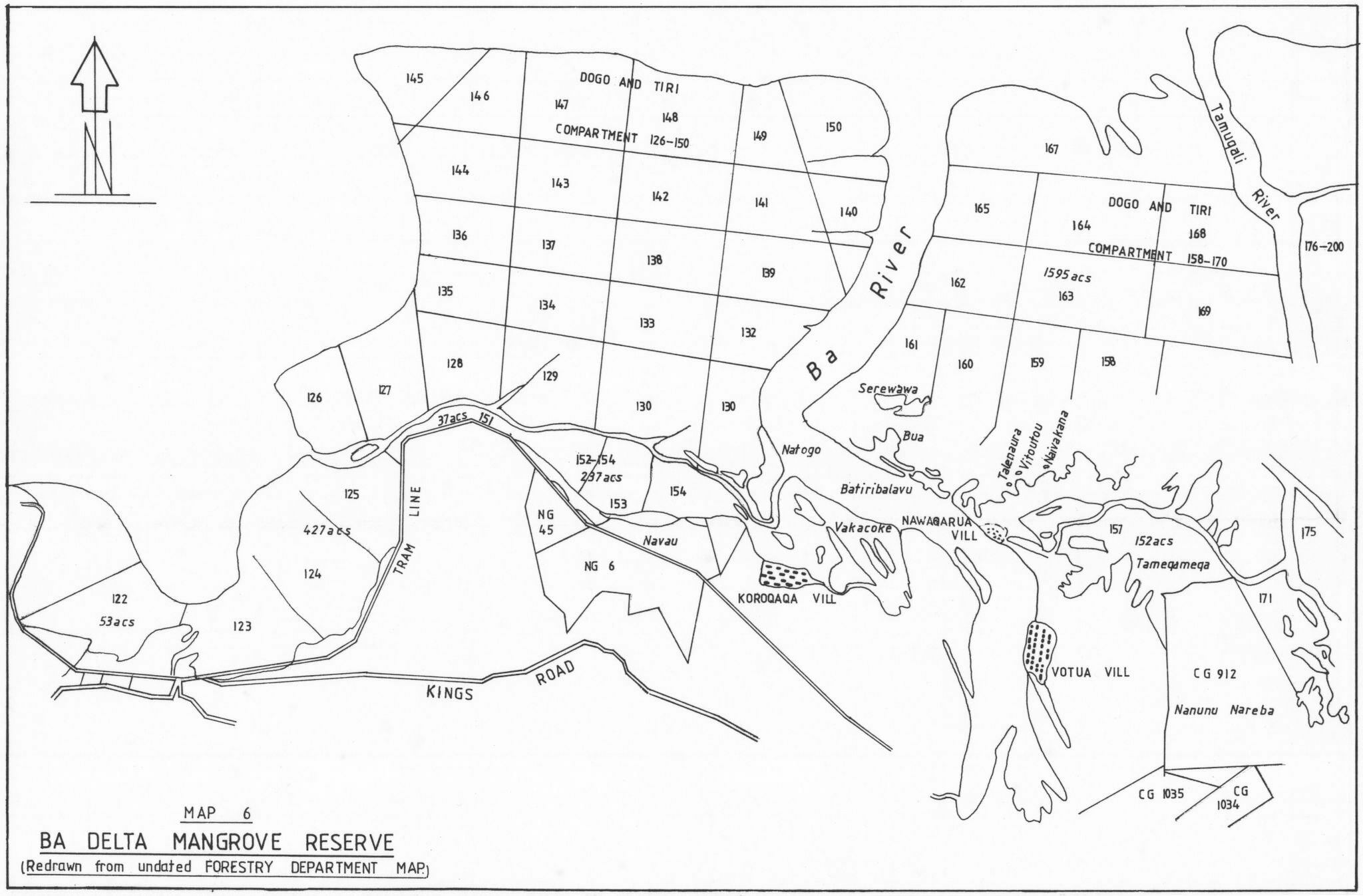
Formerly the Rewa Delta was an important source of Mangrove for industrial and domestic fuelwood. In 1945 the ‘Suva area’ produced 20,089 tons (Forestry Dept 1945). In recent years approximately 5,000 m is extracted for domestic needs. There are only two managed coups with licensed concessionares but formerly a working plan had divided the lower delta mangroves – principally Dogo Forest and Landward Alliance into coups. (Map 7, Appendix 8).
Illegal felling of mangroves is a serious but local problem, Access difiiculties probably limits this illegal felling at present. However the recent construction of the Waidamu seawall and the proposed Rewa Delta seawall will dramatically improve access and illegal felling may well become a more serious problem.
The design of the Rewa Delta sea wall should be such as to cause minimal loss of mangroves but some loss is inevitable and since over 1700 ha of land will be brought into sustained agriculture, the loss must be considered socially and economically acceptable.
The sea walls and their effect on On agricultural production may well stimulate considerable development of the delta communities and an increase in requests for localised areas of mangrove conversion – roads, jetty’s village improvements etc can be anticipated. . If properly designed these should have minimal effect in the resource but poor design changing drainage patterns can have serious repercussions.
6.4.4. Specific Management considerations
The Rewa Delta should be recognised as the most productive Mangrove Community in Fiji and the primary concern should be to preserve this productivity for both the in situ and the offshore Fisheries which sustain the subsistence and economic needs of the delta communities.
The possible impact of the present flood-mitigation dredging of the Rewa River, on the mangrove ecosystem downstream was inadequately evaluated. This was an oversight and it is even more important that it should not be repeated if further dredging is to be undertaken downstream where, argueably, Fiji’s finest mangrove stands are found.
Illegal commerical felling of the mangrove is likely to increase with the access provided by the sea – wall construction programme.
The high population density and anticipated community development will increase pressure on the Rewa Mangroves, with traditional uses evolving into more non sustainable activities. Increased management will be required but an appropriate educational/awareness programme will be vital.
Increased agricultural development will increase the risk of pollution from indiscriminate chemical use which should be monitored.
A wood production zone is identified even though not presently required. With increased access from the sea walls the two present concessions in the delta should be re-located to sites where they can be better supervised. The potential of the Dogo Forest for fuelwood supply should be fostered as it is a valuable resource and development option and in the meantime its role as a productive Alliance for the captive fisheries would be maintained.
You must be logged in to post a comment.